Planning Approval Beyond The Zones
So, you’ve got an amazing development planned and you’re ready to go! Residential in residential zone, commercial in commercial zone – all set for planning approval, right? Well, steady up, we’re going to dive a little further into Queensland’s local Council planning schemes to take a look at the finer codes that dictate the true suitability of your development.
The Planning Codes That Govern Your Development
In most Queensland local Council planning schemes, you’ll find the following types of codes:
- Zone Codes – such as medium-density residential, centre, low impact industrial, and agricultural;
- Development Codes – such as reconfiguring a lot, general development, and landscaping;
- Use Codes – such as childcare centre, home-based business, extractive industry, and residential care facility;
- Overlay Codes – such as airport, biodiversity, flood hazard, and bushfire.
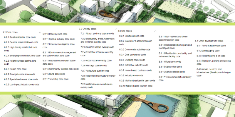
Zone Codes
These are the codes most commonly known to people – they are the division of a town or region into sections that are dedicated to particular types of development, including residential, commercial, industrial, agricultural, community, and recreation.
Your zone code is your starting point when determining the suitability of a development, it narrows down the field so that the developer can then drill down into the other codes.
Development Codes
These are the codes that dictate, generally, how the development is carried out and what standards must be met, such as earthworks, fill, emissions, landscaping, traffic flow, and infrastructure. Development codes won’t commonly rule out a particular type of development, however they provide strict guidelines for the development to adhere to.
Use Codes
Use Codes are the codes that govern specific ‘uses’. Some examples:
- If you’re building an apartment complex, you may have to adhere to a multiple dwelling use code;
- If you’re building a childcare centre, there may be a childcare use code to guide you;
- If you’re building a service station, a service station use code may be in play.
These use codes dictate what the council expects from that specific type of development, looking at things like emissions, staff and visitor ratios, car parking requirements, design guidelines, safety, and acceptable building materials.
Overlay Codes
These are similar to zone codes, in a way, just more specific. Instead of breaking a map down into sections of development type, the same map is broken down into areas affected by specific hazards and requirements. These areas, called overlays (because, once upon a time, they were literally maps that would lay over each other), can cross over and affect multiple zones. Some examples are (but not limited to):
- Certain areas of a region will have been identified as particularly prone to bushfires or flooding and so will need to address a Bushfire or Flood Hazard Overlay code – these can be broken down further within the code to correspond to risk levels;
- Biodiversity overlay codes can apply to areas that have natural environmental features such as waterways, wetlands, and protected vegetation and fauna – this code can often dictate exactly how the building needs to be designed, what size it can be, what uses are prohibited, and additional protocols that will need to be implemented if you do develop the site;
- Airport Environs overlay codes are not just about the airport grounds and surrounding air space, but also the uses and developments surrounding the airport, often up to 10km – this code determines how high your building can be, what sort of emissions are prohibited, what building materials to use to avoid things like reflections, and what uses are prohibited such as those that attract birds.
Determining Relevant Codes
So with all these codes to filter through, how do you know which ones apply to you? Here’s a basic 2-step approach:
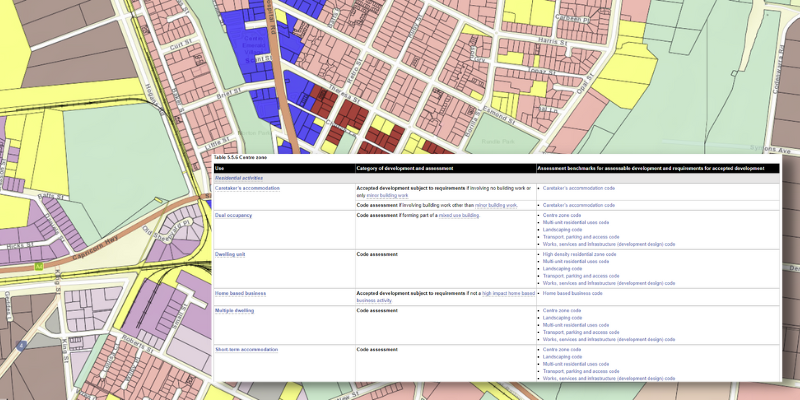
- Check the maps – on your council’s website, you will find the planning scheme with mapping (or an eplan and online mapping system). Look at the maps, find your property on each to discover what zone you are dealing with and what overlays affect the property;
- Tables of Assessment – this section of the planning scheme tabulates what types of development are specifically assessable or prohibited in each zone and what development and use codes apply to that development. Look up the zone, find the definition that matches your development and check out the results.
Chat to the Town Planning Professionals
Got a project in mind but want to be absolutely sure it ticks all the boxes? Book your initial consultation with Planning Approval Group today and kickstart that development with peace of mind.